
Where Is Golden Gate Estates on a Florida Map?
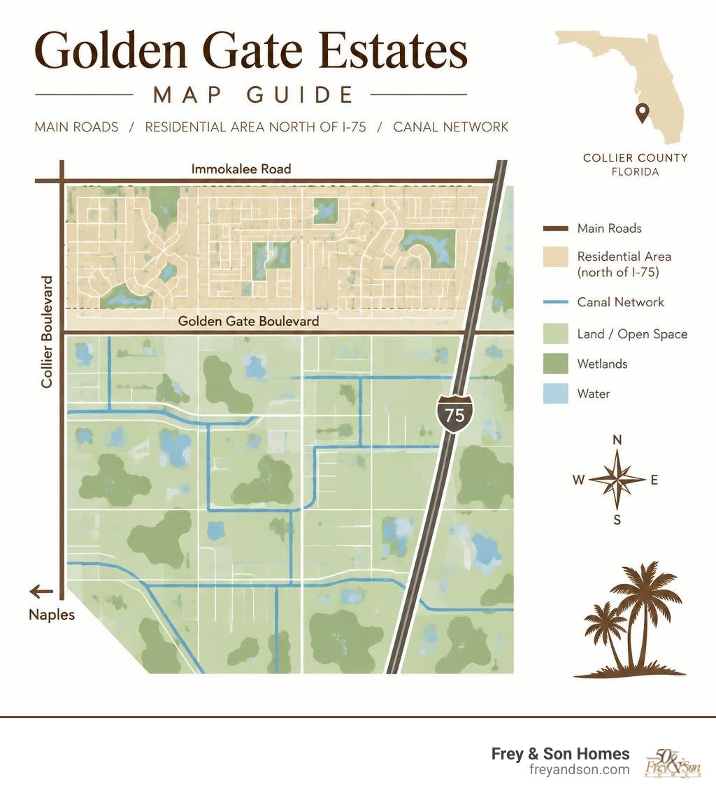
A map of Golden Gate Estates, Florida, shows a broad area of large residential lots east of Naples in Collier County. For the neighborhoods where people live today, start north of Interstate 75. Collier Boulevard marks the general western edge, Immokalee Road runs near the northern edge, and Golden Gate Boulevard is a key east-west route. The smaller, denser Golden Gate community is not the same place.
The map also tells you more than how to get around. Roads and canals cross land where lot size, wetlands, and access can change from one parcel to the next. Those details matter if you are choosing a site for a custom home.
I’m Micheal Ouellette, and I bring more than 27 years of Southwest Florida custom home building experience to this golden gate estates florida map guide. I’ll help you read the area’s layout before taking a closer look at individual lots.
Golden gate estates florida map glossary:
Reading the Golden Gate Estates Florida Map: Boundaries and Geographic Layout
When reviewing a regional map of Collier County, Golden Gate Estates occupies a distinct position east of urban Naples, centered at approximately 26.1879° N latitude and 81.6951° W longitude. The community encompasses over 53,500 acres of active residential land north of Interstate 75, stretching across eastern Collier County toward the edge of the Everglades ecosystem.
Major arterial corridors define the primary perimeter. Collier Boulevard (CR 951) frames the western border, serving as the primary north-south conduit linking residents to coastal Naples, Marco Island, and I-75. To the north, Immokalee Road (CR 846) establishes the upper boundary and provides direct transit toward North Naples, Interstate 75 (Exit 111), and eastern agricultural hubs. The southern boundary aligns along Interstate 75 (Alligator Alley), creating a clear partition between the inhabited northern acreage and state conservation lands to the south.
| Feature | Golden Gate Estates | Golden Gate CDP (City) |
|---|---|---|
| Total Land Area | ~170+ sq. miles (>53,500 active residential acres) | 4.11 sq. miles (3.90 sq. mi land / 0.20 sq. mi water) |
| Typical Lot Size | 1.14 to 5+ acres (Median: 2.27 acres) | Standard suburban residential lot (<0.25 acre) |
| Population | ~42,042 residents | 25,321 residents (2020 Census) |
| Population Density | ~633 people per sq. mile | 6,484.9 people per sq. mile |
| Zoning Classifications | Estate (E) Zoning (Single-family residential & agriculture) | Urban Residential / Commercial Multi-family |
| HOA Presence | None (Zero mandatory HOA fees or rules) | Varies by individual subdivision |
| Primary Utilities | Private potable wells and private septic systems | Municipal central water and sewer services |
Golden Gate Estates vs. Golden Gate City (CDP)
A common point of confusion for buyers exploring the area is the difference between Golden Gate Estates and Golden Gate CDP (often called Golden Gate City). While their names are similar, they represent entirely different development layouts.
Golden Gate CDP is a dense, 4.11-square-mile urban grid located approximately 8 miles northeast of downtown Naples. With a population density exceeding 6,480 people per square mile, Golden Gate City features compact residential streets, multi-family housing, public transit routes operated by Collier Area Transit (CAT), and municipal water and sewer connections.
In sharp contrast, Golden Gate Estates offers expansive multi-acre parcels where luxury homes in Golden Gate offer ultimate privacy. With lot sizes starting at a minimum of 1.14 acres up to 5 or 10 acres, population density drops to roughly 633 people per square mile. This open environment allows property owners to build private compounds, workshop buildings, and custom estates surrounded by native pine flatwoods and cypress preserves.
North vs. South Estates: Understanding the Interstate 75 Divide
The Golden Gate Estates boundary is split historically and geographically by Interstate 75.
North Golden Gate Estates (NGGE) represents all residential acreage situated north of I-75. This area contains nearly 22,000 platted residential parcels, accommodating a growing population of more than 42,000 residents with an eventual build-out capacity approaching 100,000 people. All private residential construction, school districts, local parks, and shopping corridors are situated within this northern section.
South Golden Gate Estates (SGGE), located south of I-75, was originally platted alongside the northern section during the mid-20th century. However, recognizing the severe ecological consequences of draining sensitive wetlands adjacent to the Fakahatchee Strand and Ten Thousand Islands, the State of Florida undertook a massive land reclamation project. Today, South Golden Gate Estates has been completely transformed into the protected Picayune Strand State Forest, serving as a critical wildlife sanctuary rather than a residential development.
History of the Grid: Roads, Canals, and Original Platting

Understanding the layout of Golden Gate Estates requires looking back to the late 1950s and early 1960s, when the Gulf American Land Corporation acquired more than 113,000 acres of western Collier County. Marketed at the time as the “world’s largest subdivision,” the developer laid down an extensive network of 813 miles of roads and 183 miles of drainage canals to channel surface water away from the low-lying terrain.
During the initial sales era, prospective buyers were flown over the expansive property, with sales planes landing directly on Green Boulevard—which was originally paved as a private airstrip. By 1965, roughly 90 percent of the land had been platted into individual 1.25-, 2.5-, and 5-acre parcels. Despite this massive initial civil engineering feat, fewer than 300 homes had been built by 1980, preserving the open, natural character that defines the area today.

Navigating Road Networks and Canals on the Golden Gate Estates Florida Map
The street layout of Golden Gate Estates follows an expansive grid system organized by numbered avenues and numbered streets, separated into quadrants (primarily Northeast and Northwest, with some Southwest tracts near the urban fringe).
Key east-west thoroughfares carry primary regional traffic:
- Immokalee Road (CR 846): Anchors the northernmost boundary, connecting to regional commercial centers, healthcare facilities, and I-75.
- Vanderbilt Beach Road Extension: Continues eastward through the central-northern sector, providing direct relief for east-west traffic.
- Golden Gate Boulevard: Serves as the central spine of the Estates, dividing northern and southern quadrants and providing continuous transit from Collier Boulevard eastward past Everglades Boulevard.
North-south travel relies on wide arterial connectors spaced at regular intervals:
- Wilson Boulevard: The westernmost primary north-south artery, hosting community schools and access to fairgrounds.
- Everglades Boulevard: The central north-south spine, connecting Immokalee Road down to I-75 access points.
- DeSoto Boulevard: Positions residents in the eastern acreage, providing access to larger multi-acre parcels and recreational trailheads.
The 183 miles of drainage canals running parallel to these roadways are critical to regional hydrology. As documented in the USGS topographic study of Golden Gate Estates hydrology, which evaluated the area’s 300-square-mile watershed with a fine 0.5-foot contour interval, these canals actively manage seasonal rainfall runoff, maintaining groundwater balances across residential parcels.
From Gulf American Land Corporation to Picayune Strand Restoration
While North Golden Gate Estates evolved into a thriving rural-residential community, the southern portion faced environmental challenges. The rapid drainage of nearly 20,000 platted lots in South Golden Gate Estates altered surface sheet flow into the Ten Thousand Islands estuary and increased wildfire risks across drained peat soils.
Beginning in the late 1980s, the State of Florida utilized funding vehicles including the Conservation and Recreational Lands (CARL) program, Preservation 2000, and the Florida Forever Act to acquire privately owned lots across South Golden Gate Estates. Through cooperative acquisitions and formal eminent domain proceedings, the state assembled the parcels back into public ownership.
As noted in the Golden Gate Estates municipal feasibility study, this separation solidified I-75 as the permanent southern boundary of residential development, ensuring that modern growth remains focused within the planned northern subdistricts while surrounding wetlands are preserved.
Zoning, Lot Sizes, and Property Characteristics Across the Estates
Properties in Golden Gate Estates are governed by Collier County’s Estate (E) zoning designation. This zoning framework protects the area’s rural character while providing homeowners with property rights and architectural flexibility rarely found in master-planned communities. Discovering how to enjoy spacious acreage and freedom in Golden Gate Estates starts with understanding these unique land-use rules.
Unlike suburban developments with strict architectural review boards, Golden Gate Estates has no Homeowners Association (HOA). Homeowners are not subject to monthly association fees, exterior paint restrictions, or rules prohibiting parked boats, recreational vehicles (RVs), or utility trailers on their property.
Estate (E) Zoning Regulations, Setbacks, and Non-HOA Living
Under the Collier County Golden Gate Area Master Plan, residential density is standardly limited to one single-family dwelling unit per 2.25 gross acres, though legally non-conforming 1.14-acre parcels platted prior to current regulations are common throughout the western corridors.
Standard parcel dimensions feature a uniform depth of 660 feet, with lot widths varying based on overall acreage:
- 1.14-Acre Parcels: Typically measure 75 feet wide by 660 feet deep.
- 2.27-to-2.5-Acre Parcels: Typically measure 150 to 165 feet wide by 660 feet deep.
- 5-Acre Parcels: Typically measure 300 to 330 feet wide by 660 feet deep.
Because of generous property depths, homes can be set far back from access roads behind natural pine buffers. County zoning also permits accessory structures, allowing homeowners to build detached garages, custom workshops, separate guest houses (accessory dwellings), and private pool cabanas. For landowners interested in lot splitting, county regulations mandate that the parent parcel must be at least 4.5 acres with 300 feet of road frontage, ensuring that each newly created lot maintains a minimum of 2.25 acres.
Livestock, Equestrian Rules, and Agricultural Allowances
Golden Gate Estates is one of the few areas in Collier County that permits private equestrian facilities and hobby farming. County Estate zoning allows up to two large or hoofed animals per acre (such as horses, cattle, alpacas, and llamas) on parcels 2.5 acres or larger.
Key agricultural and livestock regulations include:
- Equine & Large Livestock: Maximum of two animals per acre. All roofed livestock shelters, stables, or barns must be set back at least 30 feet from adjacent property lines and 100 feet from any neighboring residential home.
- Poultry & Fowl: Residents may keep up to 25 fowl or poultry per acre for personal use.
- Prohibited Animals: Commercial livestock operations and hogs/pigs are strictly prohibited by Collier County code, with narrow exceptions for youth 4-H educational projects lasting no more than 16 weeks.
- Crops & Private Food Forests: Cultivation of private orchards, organic food forests, and home gardens is fully permitted without agricultural business licensing.
Infrastructure, Environmental Due Diligence, and Custom Home Site Selection
Building a luxury home on acreage requires careful site preparation and environmental review. Because the landscape ranges from elevated pine flatwoods to native cypress sloughs, navigating a map of Golden Gate Estates, Florida, involves evaluating wetland boundaries, elevation profiles, and utility systems. Working alongside our team on building custom homes in Golden Gate Estates ensures every environmental and structural factor is addressed before ground is broken.
Interpreting Wetlands, Elevation, and Flood Zones on a Map of Golden Gate Estates, Florida
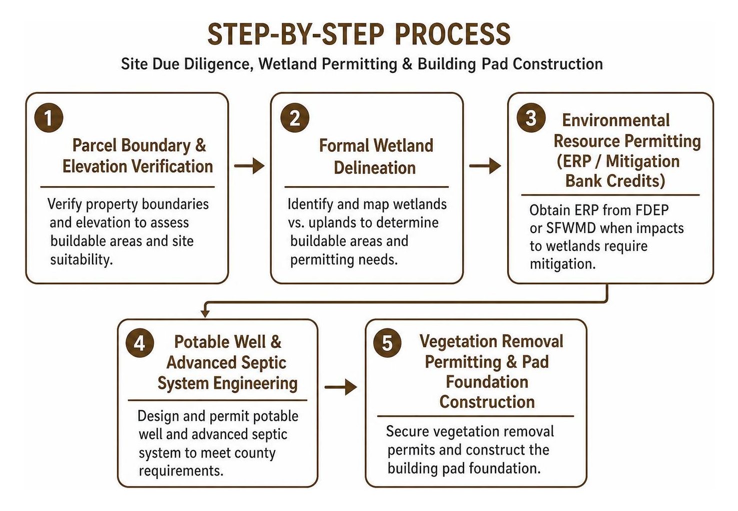
Roughly 50 percent of the parcels across Golden Gate Estates contain some degree of seasonal wetlands. The presence of wetlands does not render a parcel unbuildable, but it does influence site planning and permitting:
- Upland vs. Wetland Delineation: Upland pine terrain allows direct construction without state wetland mitigation. When a home footprint or driveway crosses designated wetland areas, an Environmental Resource Permit (ERP) from the Florida Department of Environmental Protection (FDEP) or South Florida Water Management District (SFWMD) is required.
- Mitigation Credits: Homeowners can offset wetland impacts by purchasing compensatory mitigation credits from approved regional wetland mitigation banks, allowing full site utilization for single-family residences.
- FEMA Flood Zones and Elevation Certificates: Land elevation across the Estates generally averages 10 to 18 feet above sea level. Reviewing current FEMA flood insurance rate maps (FIRMs) and securing a certified Elevation Certificate early in the planning process determines the required fill and structural finish-floor heights, safeguarding the home against seasonal tropical weather events.
Well Water, Septic Systems, and Navigating Utilities
Because Golden Gate Estates is an acreage community, properties operate independently of municipal water and sewer utilities:
- Private Potable Wells: Drinking water is sourced from private on-site wells drawing from local aquifers. Installing modern whole-home reverse osmosis (RO) or advanced water softening and filtration systems ensures high-quality water throughout the residence.
- Septic Systems: Wastewater management is handled by individual on-site septic tanks and engineered drain fields permitted through the Florida Department of Health.
- Power & Communications: Electrical service is provided by Florida Power & Light (FPL). High-speed internet is accessible via fiber connections along primary routes, fixed wireless providers, or satellite systems such as Starlink.
- Road Maintenance: While major east-west arteries and north-south connectors are maintained by Collier County, several interior access roads are privately maintained shell-rock or gravel lanes that require joint maintenance among adjacent property owners.
Lifestyle, Market Snapshot, and Community Amenities
Living in Golden Gate Estates combines peaceful rural privacy with easy access to the world-class amenities of Naples and Southwest Florida. Residents enjoy expansive private grounds, open skies, and abundant native wildlife—including deer, wild turkeys, bobcats, and swallow-tailed kites.
When evaluating your property options, reviewing our guides on navigating Golden Gate Estates real estate and homes and discovering available acreage in Golden Gate Estates provides valuable insight into local neighborhoods.
Commute Times, Local Parks, and Outdoor Recreation
Despite its secluded setting, Golden Gate Estates remains well-connected to regional hubs:
- Gulf Beaches: Vanderbilt Beach, Clam Pass Park, and Lowdermilk Park are accessible within a 25- to 40-minute drive.
- Downtown Naples & 5th Avenue South: Fine dining, upscale shopping, and cultural venues are roughly 30 to 45 minutes away.
- Airports: Naples Airport (APF) is approximately 35 to 40 minutes southwest, while Southwest Florida International Airport (RSW) in Fort Myers is reached in about 45 to 55 minutes via I-75.
Recreational amenities located directly within and adjacent to the Estates include:
- Big Corkscrew Island Regional Park: Located near Immokalee Road, this modern regional park features an aquatic center, sports fields, walking paths, playgrounds, and community event facilities.
- Belle Meade Horse Trail & Picayune Strand: Provides miles of dedicated equestrian and hiking trails through native Southwest Florida ecosystems.
- Golf Courses: Multiple public and semi-private golf layouts border the Estates, including Valencia Golf & Country Club, Arrowhead Golf Club, and nearby championship facilities across North Naples.
Real Estate Market Trends and Building Opportunities
The real estate market in Golden Gate Estates has seen steady demand from buyers seeking land, privacy, and architectural freedom.
As of late 2026, single-family homes on 2 or more acres in Golden Gate Estates list across a wide range—from approximately $430,000 for older, established homes to upwards of $3 million to $5 million for custom luxury acreage residences—with the market average centering around $1.1 million.
Vacant residential parcels provide an accessible path for custom home construction, with 1.14- to 2.5-acre homesites allowing owners to design single-story luxury layouts complete with outdoor living spaces, expansive covered lanais, resort-style pools, and detached workshops.
Frequently Asked Questions About Golden Gate Estates
What is the difference between Golden Gate City and Golden Gate Estates?
Golden Gate City (CDP) is a dense, 4.11-square-mile urban community with municipal water and sewer, smaller quarter-acre lots, and a population density over 6,400 people per square mile. Golden Gate Estates is an expansive, rural-residential acreage community north of I-75 covering more than 170 square miles, featuring lot sizes from 1.14 to 10 acres, private well and septic utilities, and a lower population density of roughly 633 people per square mile.
Are there HOA fees or building restrictions in Golden Gate Estates?
No. Golden Gate Estates operates entirely without a mandatory Homeowners Association (HOA), meaning there are zero monthly HOA dues and no restrictive HOA covenants regarding paint colors, vehicle parking, or architectural styles. All construction, guest houses, and accessory outbuildings must simply comply with standard Collier County Estate (E) zoning and building codes.
How large are the lots and can you keep horses on them?
Residential lots in the Estates typically range from 1.14 acres up to 5 or 10 acres, with a median parcel size of approximately 2.27 acres. Under Collier County Estate (E) zoning, homeowners on parcels of 2.5 acres or larger are permitted to keep up to two horses or large hoofed animals per acre, along with up to 25 poultry, provided that shelters meet required county setbacks.
Conclusion
Navigating the map of Golden Gate Estates reveals one of the most distinctive residential communities in Southwest Florida. Offering expansive acreage, architectural independence, and a natural setting, the Estates provide an ideal environment for those who desire space, privacy, and long-term value.
Building a home on acreage requires dedicated local expertise in Collier County zoning codes, environmental permitting, and site development. For more than 50 years, Frey & Son Homes has designed and constructed award-winning luxury residences across Naples, Marco Island, and Southwest Florida. Our team works with you through every phase of the process—from parcel evaluation and elevation planning to custom architectural design and construction.
Ready to find your ideal homesite? We invite you to explore premier custom home opportunities in Golden Gate Estates and begin designing your private Florida sanctuary today.